
Our Services
Land Survey Team assures its best services for all types of surveys and sub soil investigation. Daily affairs of Land Survey Team is attended by the Managing Director with highly accomplished professionals and staffs for solving problems.
Engineering Survey
The Company has got good experience in Road Alignment, Layout and Curve Setting, topographic Survey, Contour Survey and Development of Local GEOD Model and Drainage project work for a considerable period of time. Experienced and qualified man-power of the firm having expert Advisor conducting Land survey works, data processing analysis, Interpretation report preparation etc.
| SL. No. |
Project | Client | Consultant |
| 1. | Construction of A Dual Gauge Rail Line Parallel To Existing Meter Gauge Line In Dhaka – Narayanganj Section |
Bangladesh Railway | Development Design Consultant Ltd. DDC Center 47 Mohakhali C/A, Dhaka-1212 |
| 2. | Topographical Survey At 2 X 660 Mw Thermal Power Project At Banshkhali, Chittagong, Bangladesh | Shandong Tiejun Electric Power Engineering Co. Ltd. B2, Plot 13, Road #1, North Khulshi Hills R/A Chittagong, Bangladesh |
C. E. Testing Company Pvt. Ltd. 124A N.C.C. Bose Road Kolkata-700 092 |
| 3. | Detailed Feasibility Study for construction of common utility tunnel in the primary roads of Dhaka South City. | Dhaka South City Corporation | BETS Consulting Services Ltd. |
| 4. | Well field construction project at Tetuljzhora-Bhakurta area of Savar upazila for Topographical Survey | Dhaka Water Supply and sewerage Authority ( DWASA ) |
|
| 5. | Digital Topographical Survey, Contour Survey & Mapping of Shahjalal Fertilizer Project Site at Fenchuganj, Sylhet. | BCIC | |
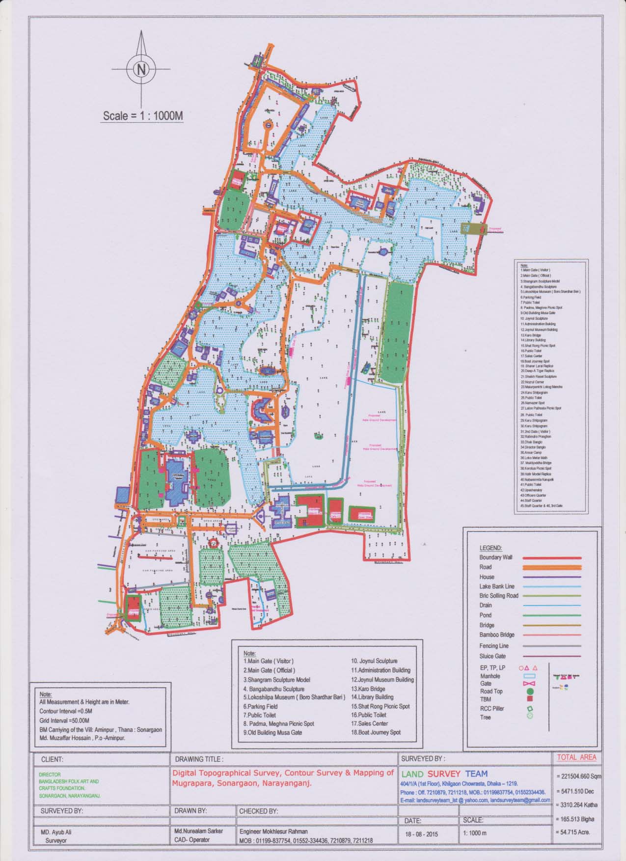
| 6. | Digital Topographical Survey, Contour Survey & Mapping of Mugrapara, Sonargaon, Narayanganj. | Director of Bangladesh Folk Art And Crafts Foundation Sonargaon, Narayanganj. | |
| 7. | Topographical Survey & Mapping of Proposed BRAC University Land Area & Within 250M Radias Width Area at Merul Badda, Gulshan, Dhaka. | Brac University, Badda, Gulshan, Dhaka. |
|
| 8. | Feasibility Study of Extra Dosed Railway Cum Road Bridge Project of Kalurghat, Chittagong. | SMEC International Pty Ltd. House # 402 (1st floor), Lane # 06, DOHS Baridhara, Dhaka-1206, Bangladesh | |
| 9. | Digital Topography Survey of Bridge Site And Approach Roads of Paira Bridge (Lebukhali Bridge), At Paira River, Barisal Patuakhali Road (N8), Bangladesh. Plan of Existing Approach Road of Paira Bridge. |
Consultancy Services For Design And Construction – Supervision of The Paira Bridge (Lebukhali Bridge) over The River Paira on Barisal Patuakhali Road (N8), Bangladesh | Intercontinental Consultants And Technocrats Pvt.Ltd. (Ict), India Kunhwa Engineering And Consulting Co.,Ltd., Korea. Narco – Dr. Nabeel Abdul – Rahman Consultants, Kuwait. Engineering And Planning Consultants Ltd., Bangladesh. |
| 10. | Design of Protective Work Along The Left Bank of The Jamuna River From Km 6.10 To Km 8.10=200 Km At Zafargonj Bazar Under Main River Flood And Bank Erosion Risk Management Program,Tranch-1 In Shibaloy Upazila Under Manikganj District |
Manikganj WD Division During The Year 2014-15 Barge Dumping Program Maps At Jamuna River (Jafarganj Bazar) Under Contract Package No: W-08/2014-2015. | |
| 11. | Bathymetric & Topographical Survey Naniarchar Dackbanglo , Naniarchar Bazar & Kaptai Lake Area at Bagachari To Naniarchar Road, Naniarchar, Rangamati, Chittagong |
19th Engineer Construction Battalion Doublemooring Army Camp, Chittagong. |
|
| 12. | Protection of ramgati and kamal nagar upazila and adjacent areas under laxmipur district from the continuing erosion of the meghna river, Laxmipur o & m division, BWDB Topographical & contour map of meghna river at alexander, laxmipur. |
Bangladesh Water Development Board (BWDB) RMBP PROJECT ALEXANDER ARMY CAMP 19 ECB, RAMGATI, LAXMIPUR |
|
| 13. | Survey works for water distribution network for Dhaka Water supply Improvement Project. Scope of Work: a)Temporary Benchmarks: i) Prior to route survey twenty(20)temporary benchmarks shall be established in the Uttara & Abdullapur Area. II) All Temporary Benchmarks should be established with PWD datum. III) The location of each temporary benchmarks shall be discussed with AQUA Engineers & decided. Iv) Based on the Temporary Benchmarks a broad point contour map shall be made. b)Route Survey: A Route survey shall be conducted to prepare the survey drawings needed for the preliminary design of the water distribution network in the Uttara & Abdullapur Area. |
Dhaka Water Supply & Sewerage Authority (DWASA) | AQUA Consultant & Associates Ltd. |
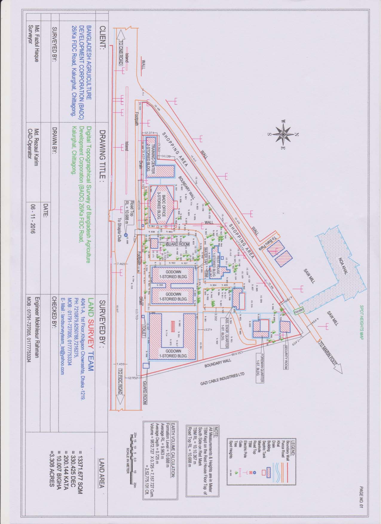
| 14. | Pre-Work & Post Work Digital Survey of Khal, Canal, Embankment, Bridge, Culvert, Pond etc. | Bangladesh Agricultural Development Corporation | |
| 15. | Topographical Survey Work under Subregional Transport Project Preparatory Facility (Road Component: Package-1) for Joydevpur-Chandra-Tangail-Hatikamrul road section. | SMEC International Pty Ltd. House # 402 (1st floor), Lane # 06, DOHS Baridhara, Dhaka-1206, Bangladesh | |
| 16. | Topographical Survey & Bathymatric Survey:-2nd Railway Bridge across Bhairob and Titas Rivers along Dhaka Chittagong MG Main Line of Bangladesh Railways | STUP-Scott Wilson JV, Dhaka | |
| 17. | Conducting Condition (Topographical) Survey for the PIRDP Irrigation Canal Systems in Upazilla Bera and Santhia of Pabna District under JMREMP during the year 2009-10. | Bangladesh Water Development Board, Asian Development Bank | |
| 18. | Digital Topographical Survey, Contour Survey & Mapping of Dhaka Opera House under Hatirjheel Area, Dhaka. | Ministry of Cultural Affairs Govt. of the people’s Republic of Bangladesh Bangladesh Secretariat, Dhaka-1000. |
|
| 19. | Topographical Survey Contour Survey & Mapping of Bangladesh National Museum. | Bangladesh National Museum Shahabag , Dhaka – 1000 |
|
| 20. | Topographical Survey Contour Survey & Mapping of Department of Public Library | Department of Public Library Shahabag , Dhaka – 1000 |
|
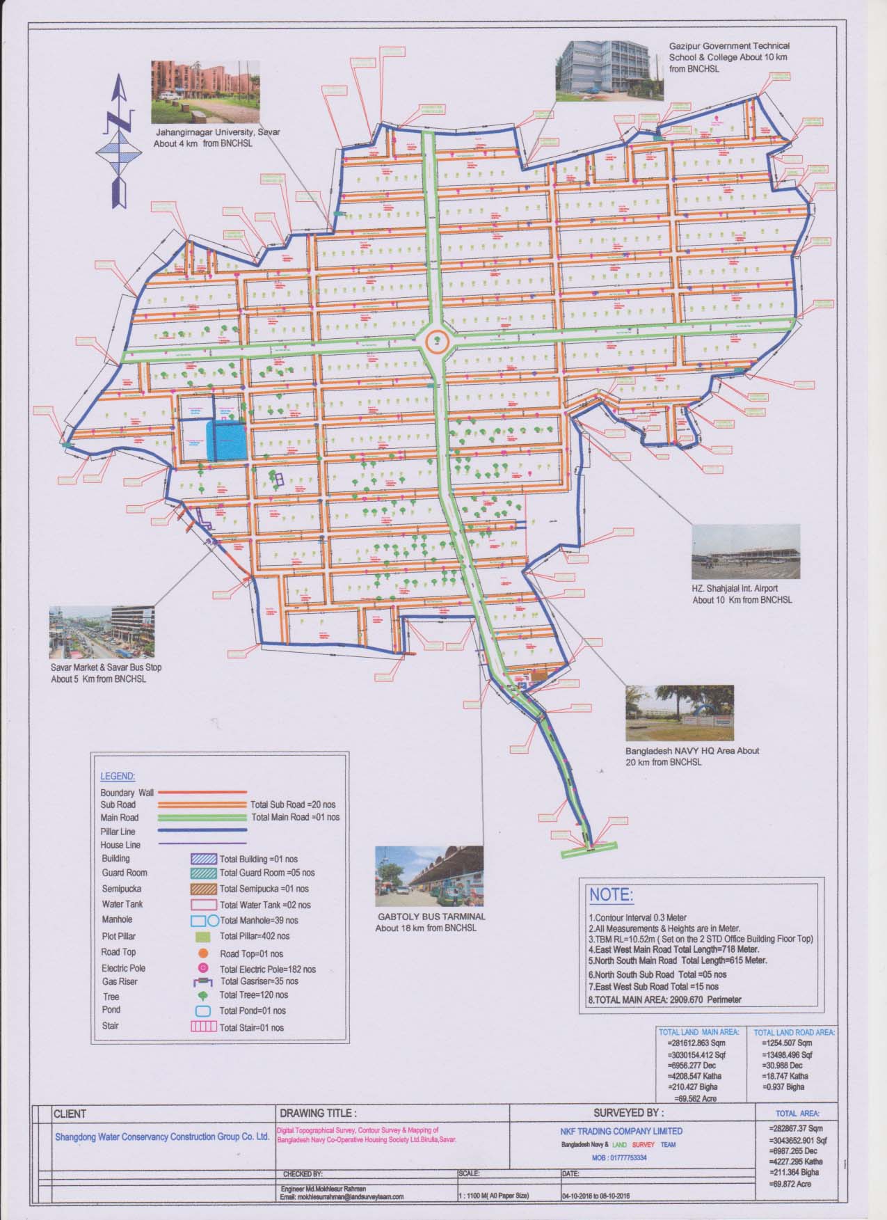
| 21. | Digital Topographical Survey Works of Bangladesh Navy Co-operative Housing Society Ltd. Birulia, Savar | Shangdong Water Conservancy Construction Group Co. Ltd. | NKF Trading Company Limited Bangladesh Navy. |
| 22. | Digital Topographical Survey & Mapping of: i) Zero Point, Jaflong, Sylhet, ii) Khamar Bari,Khidirpur (Kollogram), Khadempara-Sylhet. |
Multiplan Limited. Chandrashila Suvastu Tower (5th floor) 69/1, Panthapath, Dhaka-1205. |
|
| 23. | Topographical & Contour Map of Dhaleshwari & Kaliganga River at Manikganj in Government of The Peoples Republic of Bangladesh Ministry of Water Resources |
Executive Engineer Manikganj WD Division Shibaloy Upazila, Manikganj Bangladesh Water Development Board, BWDB |
|
| 24. | Karnaphuli Water Supply project –phase-2/W1, under Chittagong Water Supply & Sewerage Authority (CWASA) |
Kolon Global Corpration Flat No. – A4, Building No- 42-B, ABC Bay view Tower |
Njs Consultants Co., Ltd., Japan In Association With BETS, AQUA, ACE, SMEC. |
| 25. | Protective work along the left bank of the Padma River adjacent up stream to the main river training works of proposed Padma bridge at Mawa – Kandirpara Joshaldia area in Louhajong Upazila of Munshiganj District under the Padma Multipurpose Bridge Project. |
Government of the Peoples Republic of Bangladesh Ministry of Water Resources Bangladesh Water Development Board, BWDB, RMBP Project Alexander Army Camp 19 Ecb, Ramgati, Laxmipur. |
|
| 26. | Design of Protective Work Along The Left Bank Of The Jamuna River From Km 6.10 To Km 8.10=200 Km At Zafarganj Bazar Under Main River Flood And Bank Erosion Risk Management Program,Tranch-1 In Shibaloy Upazila Under Manikganj District Under Manikganj Wd Division During The Year 2014-15. | Government of the Peoples Republic of Bangladesh Ministry of Water Resources Bangladesh Water Development Board (BWDB) |
WEL-NZK-PTSL (JV) TCB Bhaban (7th Floor) 1 No. Karwanbazar, Dhaka-1216. |
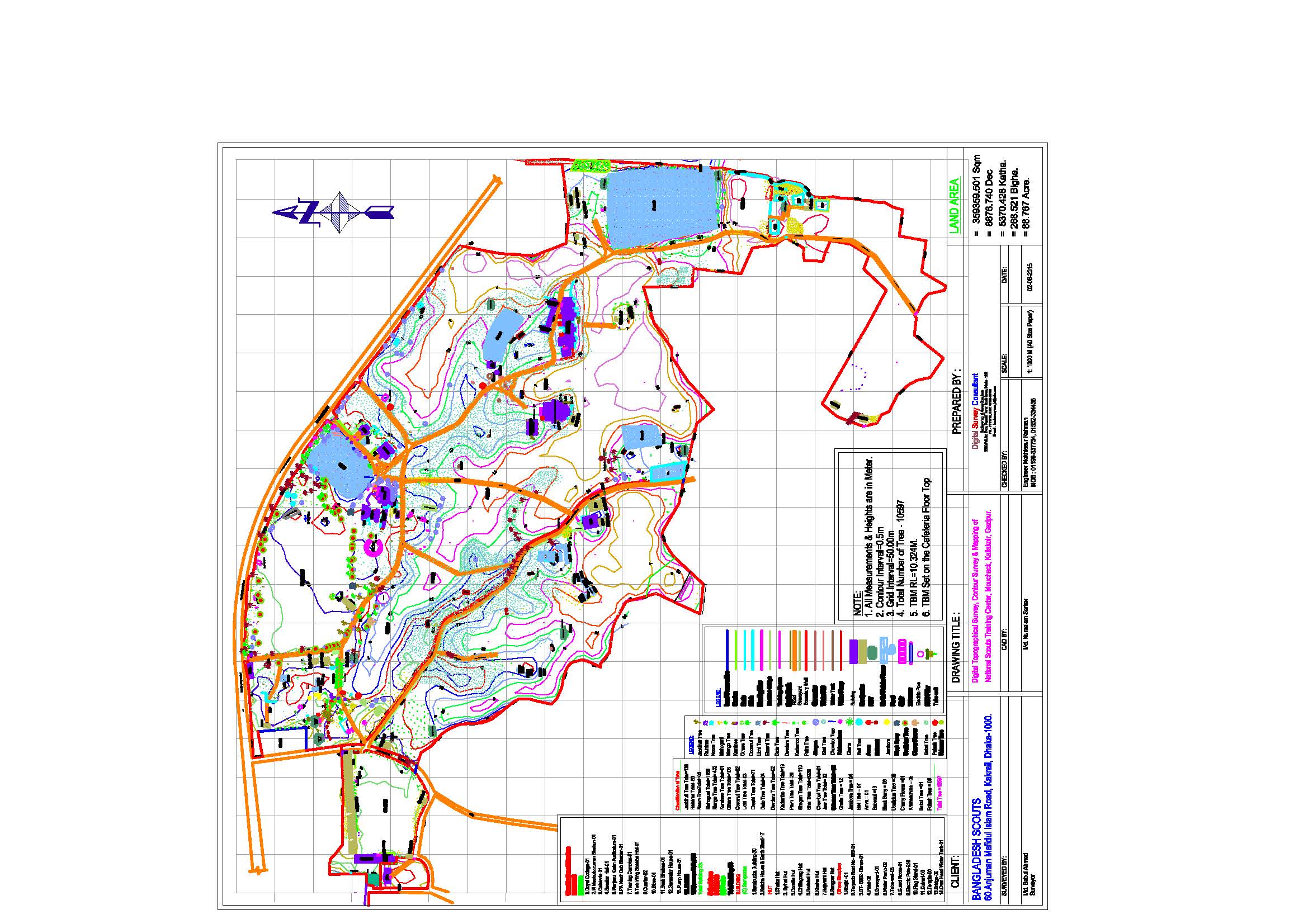
| 27. | Digital Topographical Survey & Mapping of National Scouts Training Center, Mouchack, Kaliakoir, Gazipur. | Bangladesh Scouts 60 Anjuman Mafidul Islam Road, Kakrail, Dhaka-1000. |
|
| 28. | Temporary Bank Protection work along the left bank of Padma river in between west Narisha Bazar to Meghula Bazar from km 2.812 to km 3.487=675.00 in connection with Temporary bank protective work along the left bank of Padma river at west Narisha Bazar and Meghula Bazar at Dohar Upazilla in Dhaka District under Dhaka O&M Division-2, BWDB, Dhaka during the year 2015-16 | Dhaka O&M Division-2 BWDB, Dhaka |
M/S Dolly Construction 195 Sena Kalyan Bhaban Shut No: 1602, Motijheel C/A, Dhaka-1000 |
| 29. | Bank Protection work along the right bank of Kalni River at Janatagonj bazar from km 85.500 to km 86.700= 1200m in upazilla Itna, Dist: Kishoreganj under Kishoreganj WD Division, BWDB Kishoreganj | BWDB, Kishoreganj | M/S Dolly Construction 195 Sena Kalyan Bhaban Shut No: 1602, Motijheel C/A, Dhaka-1000 |
| 30. | Jamuna-Meghna River Erosion Mitigation Project (JMREMP): (from March 2004 to July 2008) | North West Hydraulic Consultant, Canada in association with BELLER, Germany and RPMC, Bangladesh) | |
| 31. | Small-scale Water Resources Development Sectorial Project (SSWRDSP): (from January 2004 to March 2006) of LGED | LGED | in collaboration with HCL, DPM, BETS and EAA |
| 32. | As Built Drawing of Gas Transmission Capacity Expansion Ashuganj to Bakhrabad Project | GTCL | |
| 33. | Construction Works of International Boundary Pillars (Bangladesh-Myanmar Border) |
Survey of Bangladesh |
Some of Our Works

About us