
Our Services
Land Survey Team assures its best services for all types of surveys and sub soil investigation. Daily affairs of Land Survey Team is attended by the Managing Director with highly accomplished professionals and staffs for solving problems.
Geographic Information System
Geographic Information Systems (GIS) is to execute computer applications which have to accomplish database design, development and implementation facilities for GIS in Mapping, Urban Planning, Environmental Impact Analysis, Determine land use/land cover changes, Soil Mapping, Land Information System, Surveying, GIS Applications in Geology, GIS for Planning and Community Development, Collection of Information about Geographic Features etc. utilizing GIS technology.
Develop and deliver information products such as maps, charts, reports and other exhibits. Develops and maintains enterprise and workgroup-level GIS applications and databases, creating spatial analysis procedures and producing mapping products in response to business unit needs. Develop and present GIS system and cartographic mapping elements. Transpose and transform complex data from records maps, CAD drawings, town or regional land base maps, water and sewer modelling and other source documents into GIS and/or related databases. Implements and uses geo-processing tools, geospatial analysis, and map production tools to support planning and management needs and studies.
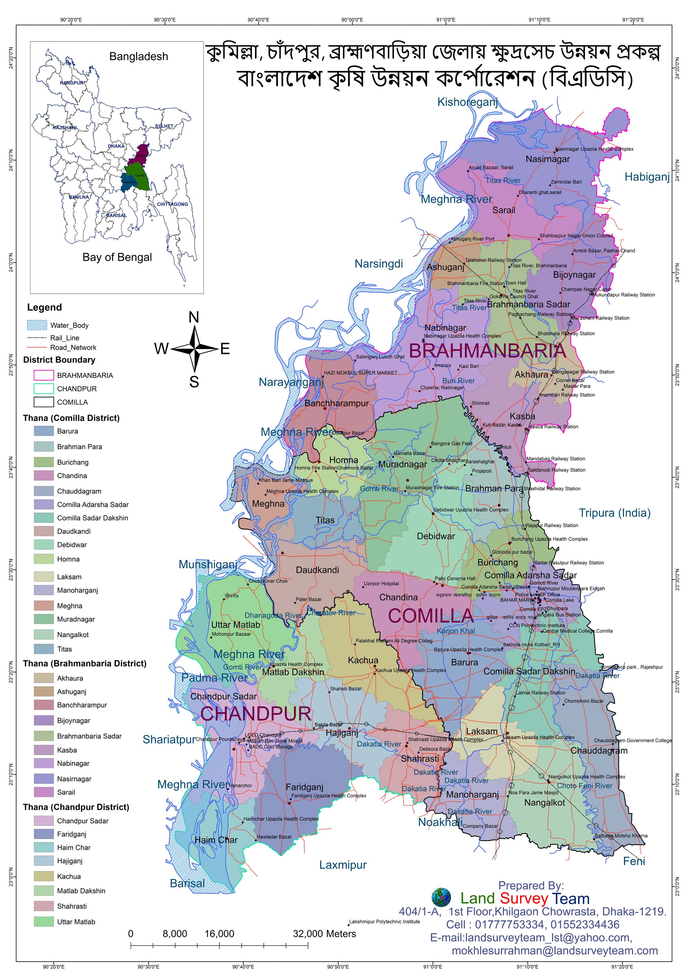
- কুমিল্লা, চাঁদপুর, ব্রাহ্মণবাড়িয়া জেলায় ক্ষুদ্রসেচ উন্নয়ন প্রকল্প ম্যাপ, বাংলাদেশ কৃষি উন্নয়ন কর্পোরেশন (বিএডিসি)
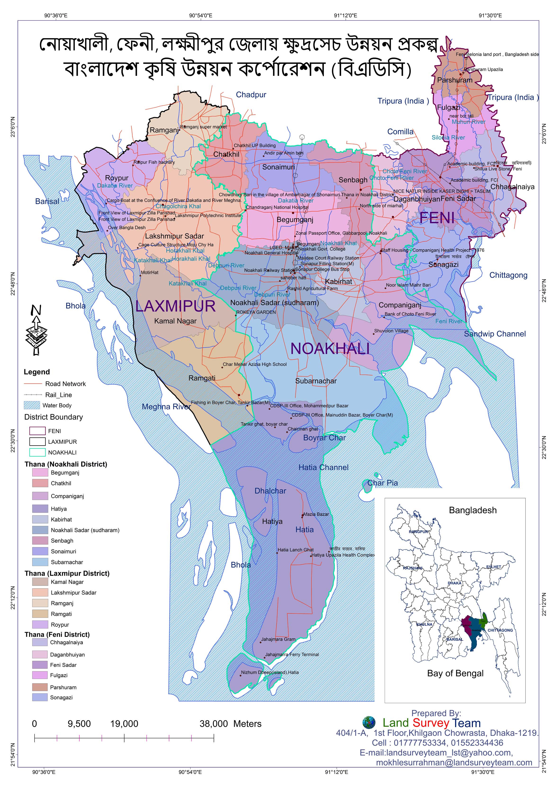
- নোয়াখালী, ফেনী, লক্ষ্মীপুর জেলায় ক্ষুদ্রসেচ উন্নয়ন প্রকল্প ম্যাপ, বাংলাদেশ কৃষি উন্নয়ন কর্পোরেশন (বিএডিসি)
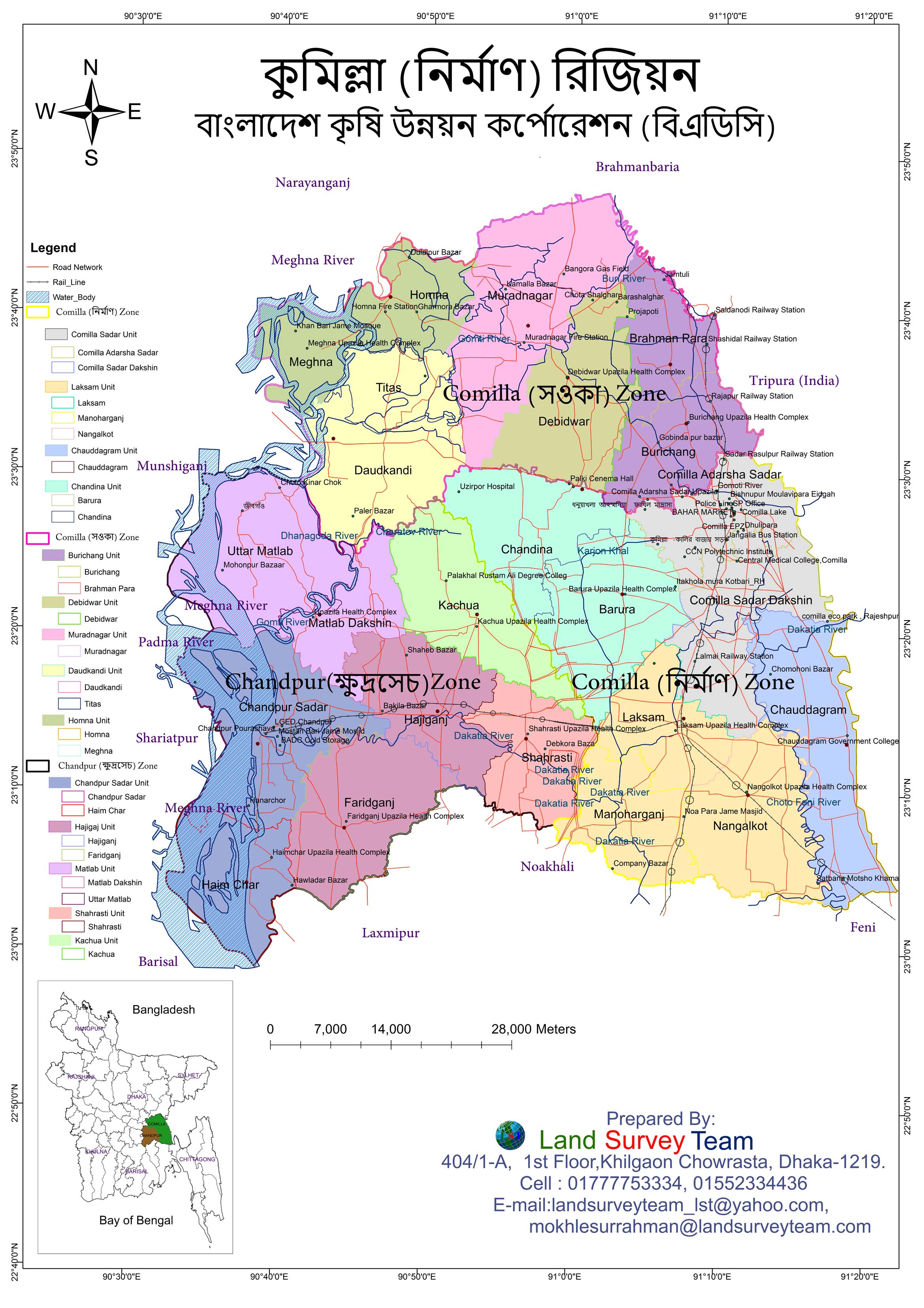
- কুমিল্লা (নির্মাণ) রিজিয়ন ম্যাপ, বাংলাদেশ কৃষি উন্নয়ন কর্পোরেশন (বিএডিসি)
- Preparation of Master Plan for Chapai Nawabganj Pourashava Third Urban Governance and Infrastructure Improvement (Sector) Project (UGIIP-III). Consulting Services for Preparation of Master Plan for Pourashava Package_ 03
- Preparation of Master Plan for Mahespur Pourashava, Upazila Town Infrastructure Development Project (UTIDP, Package No-12 Khulna Region, Government of the People’s Republic of Bangladesh, Ministry of Local Government, Rural Development and Corporation, Local Government Division.
- Preparation of Master Plan for Kaliganj Pourashava, Upazila Town Infrastructure Development Project (UTIDP, Package No-12 Khulna Region, Government of the People’s Republic of Bangladesh, Ministry of Local Government, Rural Development and Corporation, Local Government Division.
- Preparation of Master Plan for Meherpur Pourashava, Upazila Town Infrastructure Development Project (UTIDP, Package No-12 Khulna Region, Government of the People’s Republic of Bangladesh, Ministry of Local Government, Rural Development and Corporation, Local Government Division.
- Preparation of Master Plan for Bheramara Upazila, Upazila Town Infrastructure Development Project (UTIDP, Package No-12 Khulna Region, Government of the People’s Republic of Bangladesh, Ministry of Local Government, Rural Development and Corporation, Local Government Division.
- Preparation of Master Plan for Ganni Pourashava, Upazila Town Infrastructure Development Project (UTIDP, Package No-12 Khulna Region, Government of the People’s Republic of Bangladesh, Ministry of Local Government, Rural Development and Corporation, Local Government Division.
Some of Our Works
About us