
Our Services
Land Survey Team assures its best services for all types of surveys and sub soil investigation. Daily affairs of Land Survey Team is attended by the Managing Director with highly accomplished professionals and staffs for solving problems.
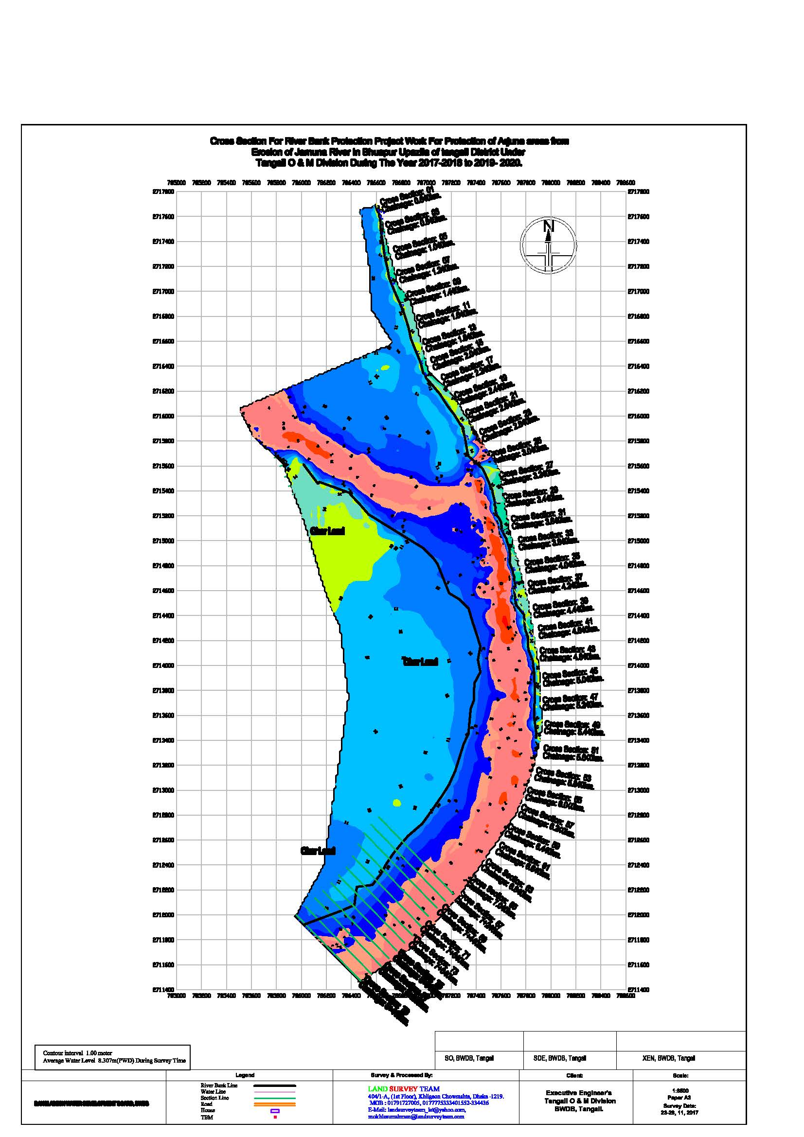
Hydro Graphic Survey
Land Survey Team conducts hydrographic survey with the use of winprofile, hydro pro, surfer and AutoCAD software. Experienced and qualified staff and officials are engaged to conduct survey works efficiently. Some of our completed projects with some sample drawings are given below:
EXPERIENCE AND CAPABILITY RIVER SURVEY
| Year | Name of Client | Name and location of Project | Contents of Work |
|
2003-08 |
Executive Engineer O & M Division, BWDB, Chandpur |
Jamuna – Meghna River Erosion Mitigation Project (JMREMP/M-1, M-15, M-16, M-18) at Ekhlaspur To Mohonpur (River Bank and wave Protection By Dumping and Placing sand filling, Geo-textile bags and concrete blocks of Meghna River) | Bathymetric Survey & Land Survey works for the project 310 Cross Section Taken @ 10m Interval (Pre Work & Post Work) |
|
2003-04 |
Ministry of Water Resources Bangladesh Water Development Board, Directorate of Planning-1. |
Chandpur Comilla Integrated FCDI Project. Consultants HCL-KRANTI-BETS-DPM,
Second Small Scale water Resources Development Sector Project, Irrigation Development In South Comilla North Noakhali Drainage Project. Zianagar To Hularhat FCDI Project. Buri-Titas Irrigation and Drainage Project. Arial Beel FCDI Project. Kushiara Bijna Project, Sherpur, Hobigonj. |
Bathymetric Survey, Engineering Survey work To Carry out the Cross Sections of Canals and Rivers and Spot Map 1193 Cross Section Taken @ 500m Interval |
|
2005-06 |
Directorate of Planning-1 (BWDB, Dhaka) | Patuakhakli Town Protection Embankment Project, Patuakhakli, Barisal.
Lalmohan-Charfesson Water Management Project, Lalmohan, Bhola. Hatia-Nijhum Dwip Cross Dam Project, Hatia, Chittagong Upgrading Of Polder 73/1a+B & 73/2 Under Coastal Embankment Rehabilitation Project Improvement Of Navigation And Environment Of The Karatoya River In Bogra Town Project |
Bathymetric Survey, Engineering Survey works to Carry out the Cross Sections and Long Sections of Khals and Rivers and Spot Map with Project Map |
|
2008 |
Banglalink Brothers Construction Nikunjo, Dhaka |
Mawa To Janjira Fiber Optical Cable Line Project Mawa, Munshiganj of Meghna River | Bathymetric Survey 11 Cross Section Taken @ 50m Interval |
|
2008-10 |
AS – TSL – (JV)
HB-TI JV Bhuiyan Mansion (2nd Floor) |
Jamuna – Meghna River Erosion Mitigation Project Koitola to Mohanganj at PIRDP of Jamuna River (Contract Package No.JMREMP/P9/2008)JMREMP/P10/2009) &JMREMP/PIRDP/W-1-2009. Of Padma River |
Bathymetric Survey & Land Survey works for the project 310 Cross Section Taken @ 5m Interval (Pre Work & Post Work) |
|
2008-11 |
M/S. ISMAIL HOSSAIN 9, Segun Bagicha, Dhaka-1000. |
Chenchuri Beel Sub–Project BWDB, Nabongonga river at Chanderchar from Km 64. 0055/0.000 to Km 64.880/0.950 Riverbank slope protection by dumping of sand filled Geo-Textile Bags and wave above Low-Water Level (LWL) cc block along the right bank of the Nabongonga river at Chanderchar at Nabaganga Riber |
Bathymetric Survey & Land Survey works for the project 96 Cross Section Taken @ 10m Interval (Pre Work & Post Work) |
|
2009-10 |
Bangladesh Water Development Board. BWDB, Dhaka |
Works in connection with the implementation of Hydrographic Survey by M.V. Anwesha under Survey & Study Division, BWDB during the year 2009-10 | Bathymetric Survey for the project 1200 Nos. Cross Section Taken @ 1.0 km Interval |
|
2009-10 |
Executive Engineer Faridpur O & M Division, BWDB, Faridpur |
Protection of Charbhatpara Regulator & Embankment of Purulia Charbhatpara FCDI Project at Upazila: Kashiani, Dist: Gopalganj |
Bathymetric Survey, Land Survey & Topographical Survey works for the project 151 Nos. Cross Section Taken @ 10m Interval |
|
2009-11 |
Executive Engineer Jamalpur O & M Division, BWDB, Jamalpur. |
River Bank Protection Work On The Left Bank Of Jamuna River From Bahadurabad Ghat To Futani Bazar ( Ch : 1200.00m To Ch :8500.00m ) In Upazilla : Islampur, Dist: Jamalpur, at Jamuna River |
Bathymetric Survey, Land Survey & Topographical Survey works for the project 1461 Cross Section Taken @ 5m Interval (Pre Work & Post Work) |
|
2010-11 |
KHULNA WASA NJS CONSULTANTS CO.LTD. |
Khulna Water Supply Improvement Project Apil gate at Bhairab River, Khulna Modumoti River, Mollahat BIWTA Ghat at Rupsha River, Khulna |
Bathymetric Survey 18 Cross Section Taken @ 200m Interval |
|
2010 |
IEL Consortium & associates Ltd. An Orion Group Company 153 & 154 Tejgaon Industrial Area, Dhaka |
Power Plant Project, Meghna River, Meghna Ghat, Narayanganj. | Bathymetric Survey, & Land Survey 21 Nos. Cross Section Taken @ 100m Interval |
|
2010 |
Maxwell 144 Shantinagar, Dhaka |
West Bank Of Jamuna Bridge – Nalka, Hatikumrul-Ishwardi -Bharamara Gas Transmission Pipeline Project. |
Bathymetric Survey, of Padma River at Pakshi Bridge 6 nos Cross Section @ 100m Interval |
|
2011 |
Programme Director, (Executive Engineer), Netrokona Badc,Nagra,Netrokona |
Programme For Construction Of Embankment Near Jaria Market, Purbodhala, Netrokona By Dredging Of Kangsha River. At Near Jaria Bazar P.S. Purbadhala, Dist.Netrokona. | Bathymetric Survey, of Kangsha River 220 nos Cross Section @ 20m Interval |
|
2011 |
Michio OTA JICA Expert (Advisor on River Management) Bangladesh Water Development Board (BWDB) Wapda Building Motijheel C/A, Dhaka |
Digital Topographical Survey, Cross Section Survey & Spot Elevation Of Padma River at Hasail, Tongibari Munshiganj. Digital Topographical Survey, Cross Section Survey & Spot Elevation Of Padma River at Lohajang, Tongibari Munshiganj. |
Bathymetric Survey, Land Survey & Topographical Survey works for the project 41 Cross Section
Taken @ 50m Interval |
|
2011 |
SMEC International Pty Ltd. House # 402 (1st floor), Lane # 06, DOHS Baridhara, Dhaka-1206, Bangladesh. |
Feasibility Study Of Extra Dosed Railway Cum Road Bridge Project Of Karnaphuli River, Kalurghat, Chittagong. At Karnaphuli River |
Bathymetric Survey, Land Survey & Topographical Survey works for the project 31 Cross Section Taken @ 100m Interval |
|
2012 |
Bangladesh Water Development Board BWDB, Dhaka M/S Ismail Hossain 9 Segun Bagicha, Dhaka |
South-West Area Integrated Water Resources Planning and Management Project Cross Section of Modumoti River Under Kashiani Upzila of Gopalganj District |
Bathymetric Survey & Land Survey for the project 116 Cross Section Taken @ 10m Interval (Pre Work & Post Work) |
|
2012 |
Bangladesh Water Development Board Aqua Dredging Ltd. Bongo Dredging Ltd. SS & RCL Dredging Ltd. BGME Bhaban, Kawaran Bazar, Dhaka. |
Pilot Capital Dredging, at Jamuna River | Bathymetric Survey 691Cross Section Taken @ 10m Interval (Pre Work & Post Work) |
|
2012 |
Bangladesh Water Development Board M/S Tajul Islam |
Pilot Capital Dredging, Pungli River Mirzapur, Tangail. | Bathymetric Survey 53 Cross Section Taken @ 50m Interval (Pre Work & Post Work) |
|
2012 |
Bangladesh Water Development Board Aqua Dredging Ltd. |
Pilot Capital Dredging, Pungli River Mirzapur, Tangail. | Bathymetric Survey 53 Cross Section Taken @ 50m Interval (Pre Work & Post Work) |
|
2013 |
Executive Engineer Jamalpur O & M Sub-Division, BWDB, Jamalpur. |
Jamuna – Meghna River Erosion Mitigation Project ( JMREMP ) Contract Package No.BFB-RBP-24/2011-12 Contour Map at U/S of Futani Bazar of left Bank of Jamuna River of Segment Futani Bazar to Bahadurabad From ( CH : 000M TO CH :1250.00M ) In Upzilla : Islampur, Dist: Jamalpur, Under Jamalpur O & M Sum-Division, BWDB, Jamalpur. |
Bathymetric Survey 85 Nos Cross Section Taken @ 50m Interval (Pre Work & Post Work |
|
2013 |
BANGLADESH WATER DEVELOPMENT BOARD (BWDB) | Contract Package No: SWAIWRPMP/P-1/2012-13 Parmamenant River Bank Slope Protection work Along the Right Bank of the Contour Map of Nabaganga River at Islampur in the month of November, 2013. At Chainage = 59.860km To 60.360 Km= 0.500 km |
Bathymetric Survey 53 Nos Cross Section Taken @ 10m Interval (Pre Work |
|
2013-14 |
M/S. ISMAIL HOSSAIN 9, Segun Bagicha, Dhaka-1000. |
Chenchuri Beel Sub–Project BWDB, Nabongonga river at Mowli Bazar Riverbank slope protection by dumping of sand filled Geo-Textile Bags and wave above Low-Water Level (LWL) cc block along the right bank of the Nabongonga river at Chanderchar at Nabaganga Riber |
Bathymetric Survey & Land Survey works for the project 204 Cross Section Taken @ 5m Interval (Pre Work & Post Work) |
|
2013-14 |
Chittagong water Supply & Sewerage Authority (CWASA) NJS CONSULTANTS CO., LTD., JAPAN In association with BETS Consulting Service Ltd., Bangladesh |
Karnaphuli Water Supply project –phase-2, | Bathymetric Survey & Land Survey works for the project 100 Cross Section Taken @ 50m Interval |
|
2014-17 |
Bangladesh Water Development Board (BWDB) RMBP PROJECT ALEXANDER ARMY CAMP 19 ECB, RAMGATI, LAXMIPUR |
Protection of ramgati and kamal nagar upazila and adjacent areas under laxmipur district from the continuing erosion of the meghna river, Laxmipur o & m division, BWDB Bank Protection Works at Char Alexander & Adjoining Areas (Location -2, Km 132.000 to Km135.500 = 3500m) |
Bathymetric Survey & Land Survey works for the project 180 Cross Section Taken @ 20m Interval |
|
2015-16 |
Bangladesh Water Development Board (BWDB) SWO – WEST 17 ENGINEERING CONSTRUCTION BATTALION MIRPUR ARMY CAMP, DHAKA- 1216. |
Protective work along the left bank of Padma River adjacent upstream to the main river training works of proposed Padma Bridge at Mawa -Kandirpara-Joshaldia area from km. 6.00 to km. 7.30 for a total length of 1300m in Louhajong upazila of Munshigonj District under the Padma Multipurpose Bridge Project. |
Bathymetric Survey & Land Survey works for the project 66 Cross Section Taken @ 20m Interval |
|
2015-16 |
Bangladesh Water Development Board (BWDB) WEL-NZK- PTSL (JV) TCB Bhavan, 7th Floor, 1, Kawranbazar, Dhaka-1216 |
Design of Protective work along the left bank of the Jamuna River from km 6.10 to km 8.10=200 km at Zafargonj Bazar under main river flood and bank erosion risk Management program,tranch-1 in Shibaloy upazila under Manikgonj District under Manikgonj wd Division During the year 2014-15 Contact Package no: W-08/2014/15 |
Bathymetric Survey & Land Survey works for the project 121 Cross Section Taken @ 20m Interval |
|
2015-17 |
Muhuri Irrigation Project (MIP) Bangladesh Water Development Board (BWDB) Anzdec Limited (NZL) in association with BETS Consulting Service Ltd. & Bangladesh Engineers Ltd. |
Estimate for Rehabilitation Costal Embankment, Re-Excavation of Khals Group -1 & Re-Excavation of Khals Group -2 in C/W IMIP Project under Feni O & M Division, BWDB, Feni during the year 2014-15 & 2015-16 (Package No – CW – 1)0 |
Bathymetric Survey & Land Survey works for the project 50 Cross Section Taken @ 50m Interval |
|
2014-15 |
STUP-Scott Wilson & Development Design Consultant JV,47 Mohakhali, Dhaka | Topographical & Bathymetric Survey:-2nd Railway Bridge across Bhairob and Titas Rivers along Dhaka Chittagong MG Main Line of Bangladesh Railways | Bathymetric Survey & Land Survey works for the project 100 Cross Section Taken @ 20m Interval |
|
2014-15 |
ILF Consulting Engineers. BETS Consulting Service Ltd., Bangladesh |
Feed& PMC for Installation of a SPM and Pipeline System Moheshkhali, Chittagong | Bathymetric Survey & Land Survey works for the project 100 Cross Section Taken @ 10m Interval |
|
2014-16 |
AS – TSL – (JV) | Slope Protection of Embankment by C.C. block including construction of surface drainage outlet structure and River bank Protection work by dumping of sand filled Geo-textile bags including supplement dumping and flood stand by from Koitola to Mohanganj at PIRDP (Contract Package No. JMREMP/P9/2008) & JMREMP/P10/2009) | Bathymetric Survey & Land Survey works for the project 50 Cross Section Taken @ 91m Interval |
|
2013-14 |
Bangladesh Water Development Board, Asian Development Bank Project Director JMREMP.BWDB, Dhaka. |
Conducting Condition (Topographical) Survey for the PIRDP Irrigation Canal Systems in Upazilla Bera and Santhia of Pabna District under JMREMP during the year 2009-10. Contract Package No. JMREMP/PIRDP/W-1-2009. |
Bathymetric Survey & Land Survey works for the project 50 Cross Section Taken @ 150m Interval |
|
2013-14 |
Bangladesh Water Development Board, Asian Development Bank Project Director JMREMP.BWDB, Dhaka |
Conducting Condition (Topographical) Survey for the PIRDP Irrigation Canal Systems in Upazilla Matlab of Chandpur District under JMREMP during the year 2009-10. Contract Package No. JMREMP/MDIP/W-1-2010. |
Bathymetric Survey & Land Survey works for the project 100 Cross Section Taken @ 18m Interval |
|
2015-16 |
Bangladesh Agricultural Development Corporation (BADC) | Bathymetric Survey Of Char Bashbaria, Dashmina, Patuakhali | Bathymetric Survey & Land Survey works for the project 50 Cross Section Taken @ 61m Interval |
|
2015-16 |
Executive Engineer Jamalpur O & M Division, BWDB, Jamalpur. |
Jamuna – Meghna River Erosion Mitigation Project (JMREMP) Bathymetric & Topographical Survey of Bahadurabad Railway Ghat Footoni Bazar, Dewangonj, Islampur, Jamalpur |
Bathymetric Survey & Land Survey works for the project 20 Cross Section Taken @ 51m Interval |
|
2016-17 |
Executive Engineer Dhaka O & M Division-2 BWDB, Dhaka. Dockyard and Engineering Works Ltd. Contract Package No.DPM / Braha Bazar-01/15/16 Bangladesh Navy, Shonakanda, Bandar, Narayangonj. |
Bank Protection work along the left bank of Padma River from Aurangabad to Braha Bazar Ghat at Dohar Upazila in Dhaka District under Dkaka O & M Division-2, BWDB, Dhaka During the Year 2015-16, 2016-17 & 2017-18 |
Bathymetric Survey & Land Survey works for the project 71 Cross Section Taken @ 50m Interval |
|
2016-17 |
Executive Engineer Dhaka O & M Division-2 BWDB, Dhaka.M/S Dolly Construction 195 Sena kalyan Bhaban, Shut No.1602, Motijheel C/A, Dhaka-1000. |
Temporary Bank Protection work along the Left bank of Padma River In between west Narisha Bazar to Meghula Bazar from Km. 2.812 to Km. 3.487 = 675.00 m in connection with Temporary Bank Protective work along the Left bank of Padma River at west Narisha Bazar and Meghula Bazar at Dohar Upazila in Dhaka District under Dhaka O & M Division – 2 BWDB Dhaka during the year 2015-16. |
Bathymetric Survey & Land Survey works for the project 20 Cross Section Taken @ 34m Interval |
|
2016-17 |
M/S Dolly Construction 195 Sena kalyan Bhaban, Shut No.1602, Motijheel C/A, Dhaka-1000. |
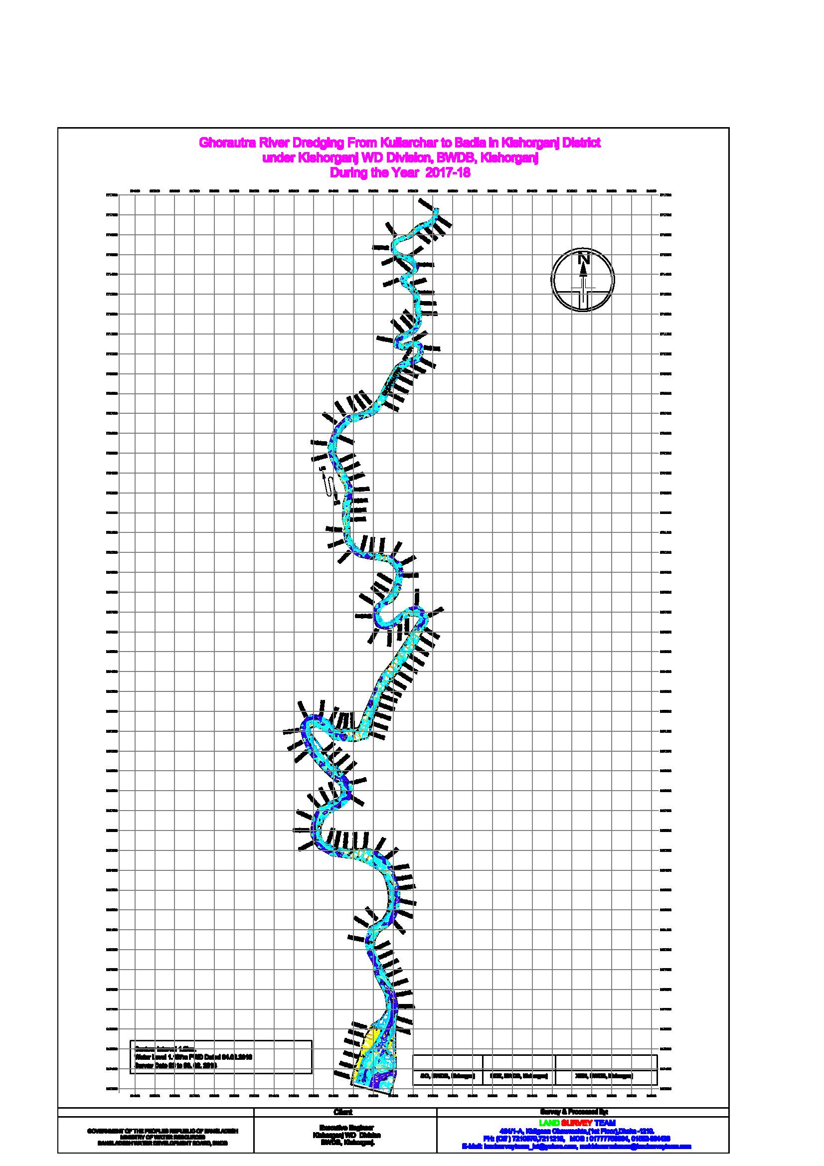
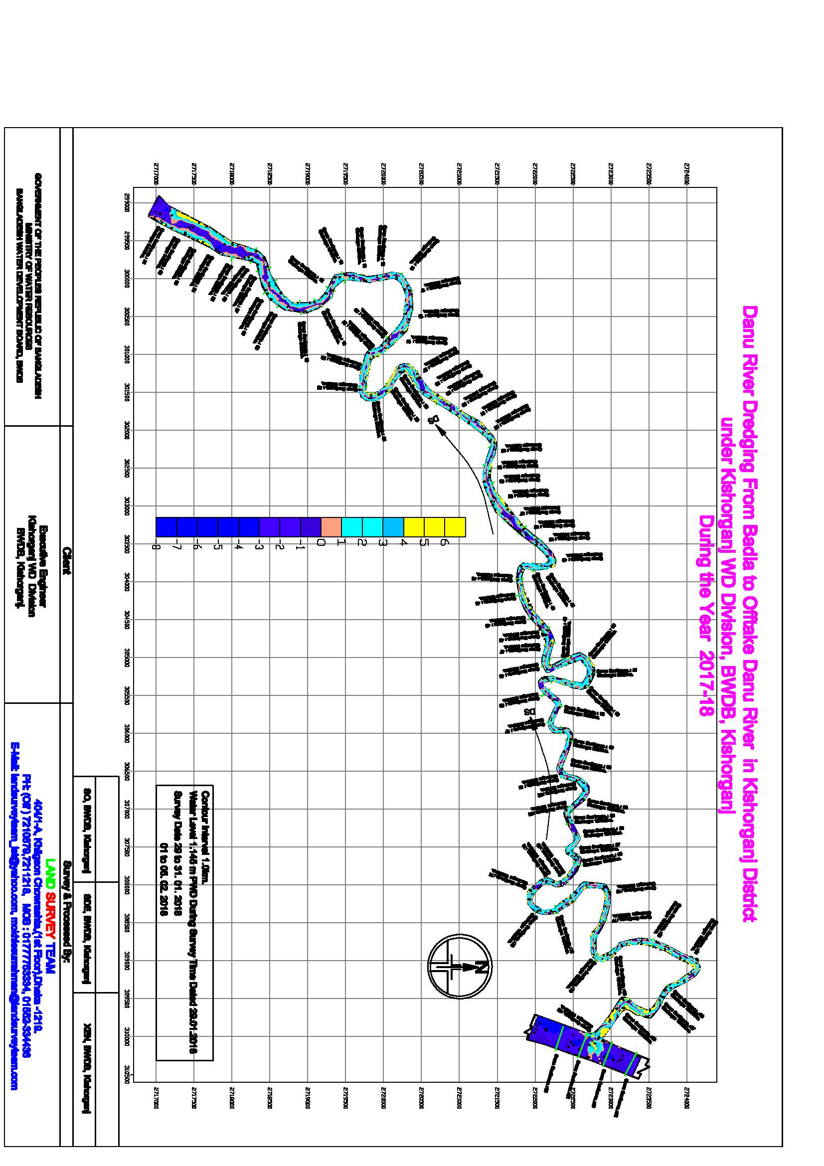
Bank Protection work along the Left bank of Kalni River at Kadamchal Bazar From Km. 68.80 to Km. 68.540 = 260m in Upazilla Austogram, Dist: Kishoreganj under Kishoreganj WD Division, BWDB Kishoreganj. Package No : BWDB/Kish/Kalni-Kushi/PW-01 |
Bathymetric Survey & Land Survey works for the project 13 Cross Section Taken @ 20m Interval |
|
2016-17 |
Executive Engineer Manikganj WD Division Joyra, Manikganj Bangladesh Water Development Board, BWDB |
Flood and Riverbank Erosion Risk Management Investment Program River Bank Protection Work at Horirampur under Manikganj WD Division, BWDB Manikganj Bathymetric & Topographical Survey of Padma River, February 2017 |
Bathymetric Survey & Land Survey works for the project 161 Cross Section Taken @ 50m Interval |
|
2016-17 |
Executive Engineer Manikganj WD Division Joyra, Manikganj Bangladesh Water Development Board, BWDB |
Topographical & Bathymetric Survey:-Contour Map of Jamuna River At Jafarganj Bazar To Paturia, Shivalaya, Manikganj |
Bathymetric Survey & Land Survey works for the project 51 Cross Section Taken @ 100 m Interval |
|
2016-17 |
BANGLADESH POWER DEVELOPMENT BOARD
EPC Contractor: Marubeni Corporation |
Bibiyana-Iii, 400 Mw Gas Based Combined Cycle Power Plant Project Kushiyara River Bathymetric Survey for River Water Intake Channel |
Bathymetric Survey & Land Survey works for the project 21 Cross Section Taken @ 10m Interval |
|
2016-17 |
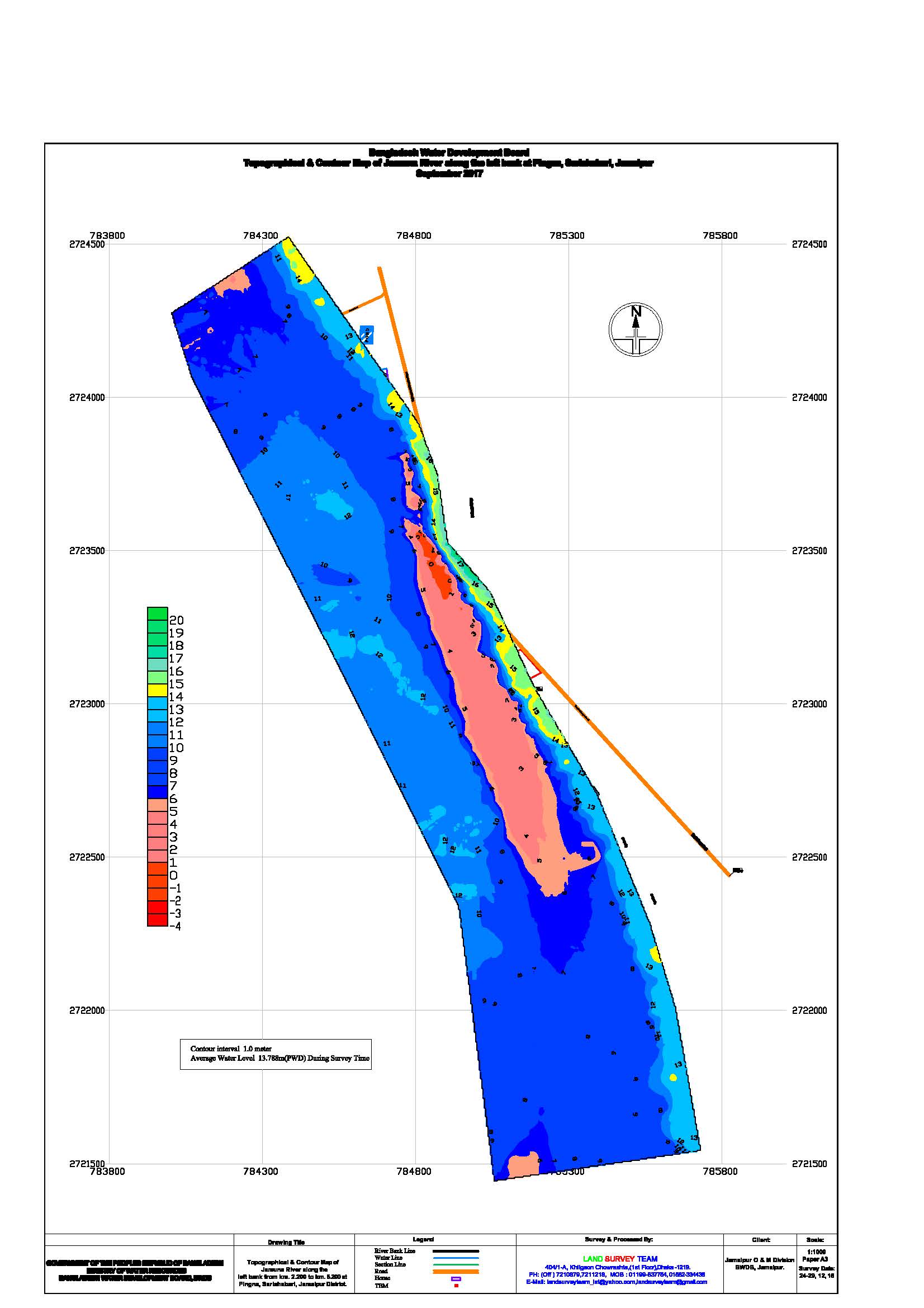
Bangladesh Water Development Board Jamalpur O & M Division BWDB, Jamalpur. |
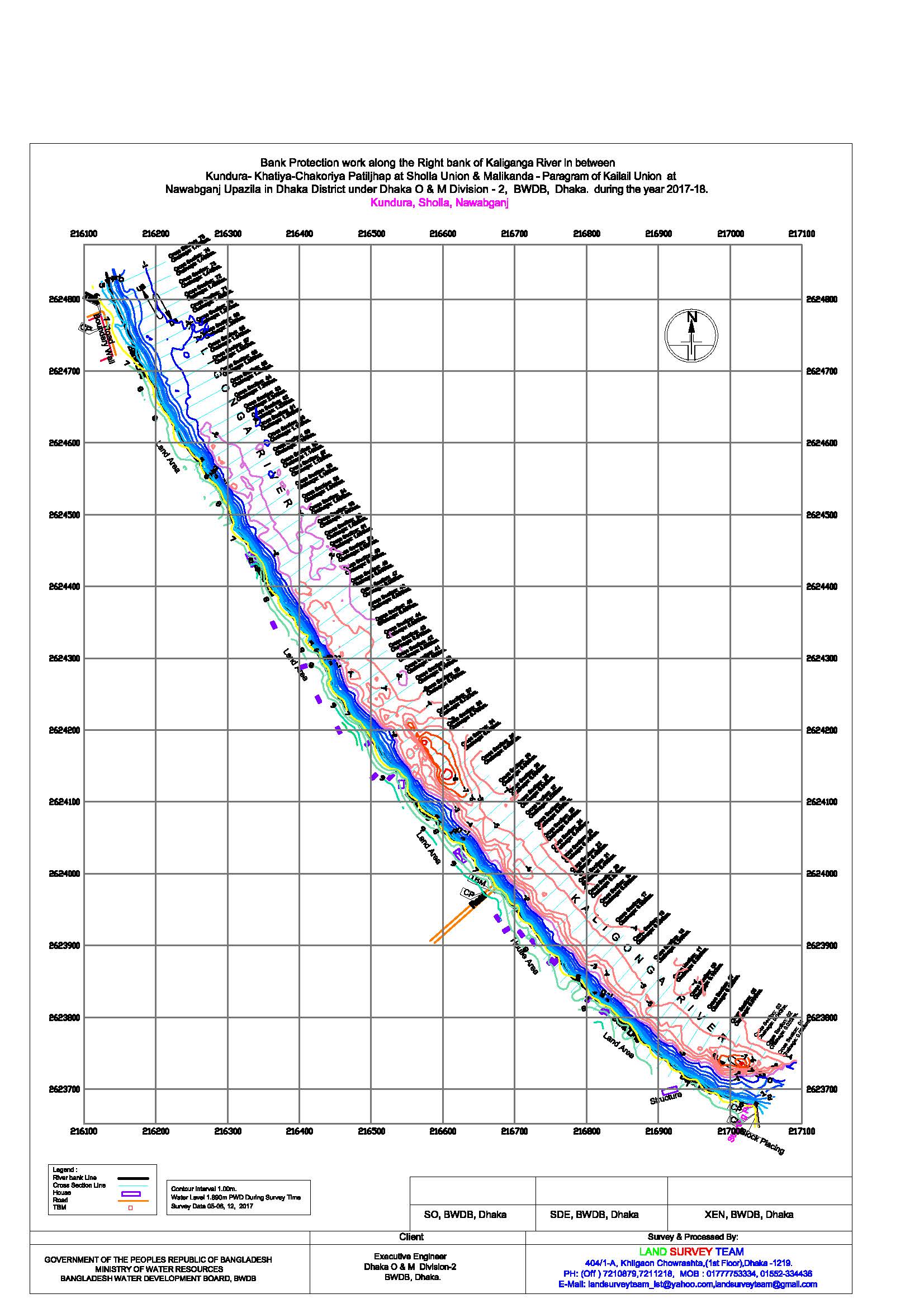
Topographical & Contour Map of Jamuna River along the left bank from km. 2.250 to km. 5.200 at Pingna, Sarishabari, Jamalpur District |
Bathymetric Survey & Land Survey works for the project 59 Cross Section Taken @ 50m Interval |
|
2016-17 |
The Executive Engineer, Manikganj W.D. Division, BWDB, Joyra, Manikganj | Bathymetry Survey along the Jamuna river from coordinate 23054´71´´N , 89044´48.3´´ E to coordinate 23048´57.46´´N, 89046´10´´E for preparation of design data for dredging work in Manikganj district under non development revenue budged during the year 2016-2017 | Bathymetric Survey (Deposit work only) Secondary River (Width ≥ 500m) Basis : 200 km-transact: spaced at 200 m interval |
|
2016-17 |
The Executive Engineer, Manikganj W.D. Division, BWDB, Joyra, Manikganj | Bathymetry Survey along the Padma river from km 0.00 to km 11.300 = 11300 m for the assessments of flood damage on the river bed at Horirampur Upazila in Manikganj district under Flood and Riverbank Erosion Risk Management Investment Program (FRERMIP) during the year 2016-2017. | Bathymetric Survey (Deposit work only) Secondary River (Width ≥ 500m) Basis : 200 km-transact: spaced at 200 m interval. |
|
2016-17 |
The Executive Engineer, Manikganj W.D. Division, BWDB, Joyra, Manikganj | Bathymetry survey in the Kaliganga and Dhalashwari river at 25 location total length 25 km for preparation of design data for bank protection work in Manikganj district under non development revenue budged during the year 2016-2017 | Bathymetric Survey (Deposit work only) Secondary River (Width ≥ 500m) Basis : 200 km-transact: spaced at 200 m interval. |
Some of Our Works
About us